Yesterday (February 29, 2008), I attempted a new trail, Rocktop. It is a 1.5 mile strenuous trail that is mostly upward with many hazards associated with mountain climbing. The trail is quite nice. On Pinnacle you can only see the mountain ahead of you and the trees that you have already passed, but on Rocktop you get many opportunities for some very nice views as you ascend the mountain. At about the middle of the trail you can see the radio and other communication towers that are located at the peak. That is where the hike ended for me. I have for a long time had a fear of heights. This fear occurs only when I can see the ground below me through a straight line descending down, such as while hiking up a trail without many curves (Rocktop). While I turned back this time, next time I intend to take the trail all the way to the top.
And now for some GPS data….

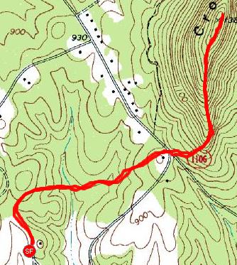
The overall trail. The trail to the west of the road is the first half of Crowders trail. Once crossing the road there is an option, continue on Crowders (a less rocky, but more winding trail to no where… ) or go to the right and head up Rocktop. On this map, everything highlighted to the east of the road is Rocktop.
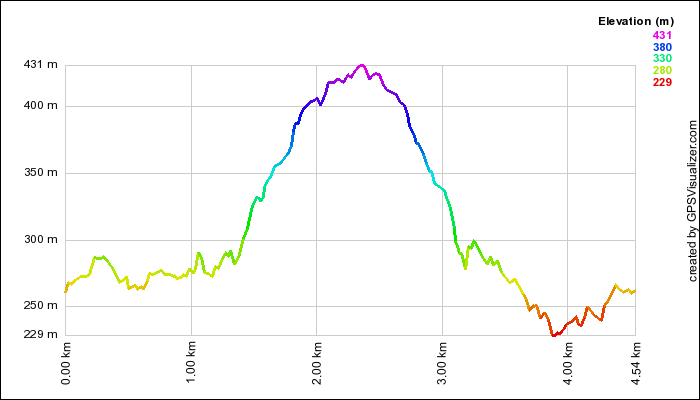
This is an elevation profile like the one in my previous post. It shows with its curve and with color, the level of height

Here is a new way to look at it, it is overlayed on the same map as the usual Google Earth maps. The altitude is shown in varying colors, indicated by the key on the side.

This is a speed profile that shows how fast (or slow) I was going during the hike. Obviously, as the hills become more steep, I became more sluggish. There are also a few points during which I stopped to take a break.
If you are interested in all of the details of the hike, they are located at http://www.livecurt.net/gps/20080229.html.